
Up The Whangie
- Jan 2
- 3 min read
After several days of rain, a couple of bright days prompted us to get out and make a return visit to a popular local attraction for locals, tourists and climbers known as The Whangie

Access to this remarkable geological feature is obtained from the Queen’s View Car Park on the A809, about halfway between Milngavie and Drymen. A small charge has recently been introduced to the parking to finance litter collection and maintenance. £2 for the first hour and £1 per hour thereafter at the time of writing. Payment is via a phone app. We anticipated our trip would take around 2 to 3 hours.

From the car park, a stone stile over a drystone wall takes you to the foot of the path leading up Auchineden Hill. The path is well-defined and relatively easy-going. Care should be taken in icy conditions, though.
It was not long before our ascent revealed fabulous views, north towards Loch Lomond and westwards towards Killearn, Balfron and the Forth Valley.

To the left, a fence bordered a woodland plantation during our ascent.. When we reached the end of the fence, we turned left off the path to follow a steeper route upwards. This took us to the plateau-like summit of Auchineden Hill from where we could see the edge of Glasgow through the misty afternoon sunshine.

To the west, the clear lump of the Campsies was clear with the famous Dumgoyne Hill at its eastern end, with the lesser known sister hill (but almost as high) Dumfoyn. The burn running down from Dumgoyne was the original water supply forthe Glengoyne distillery at the foot of the hill. An excellent tour can be had at this distillery, culminating in samples of its outstanding Glengoyne whisky.

We made our way across the plateau along well-defined paths, boggy in places, until we reached the triangulation pillar at the summit. After taking in more of the vistas, we commenced our descent in the direction of the distant Loch Lomond. Following the path around the side of the hill, we were soon at the feature known as The Whangie.

A whangie in Scots means a slice – and this is how the feature got its name. It is as though a huge knife has sliced out lumps of the igneous basalt from the side of the hill, leaving a deep cut ravine and assorted rocky masses. This feature is, needless to say, very popular with climbers. Many make the trip out from Glasgow to practice their skills on the assortment of rock faces. Not so many on the day we visited, though, as the weather was bitterly cold with patches of ice here and there.

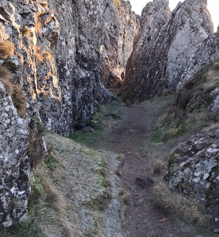


Geologists theorise that Glacial Plucking caused the exposed basalt to split and shatter forming the deep cleft in the rock.
There is a legend that the devil, being upset at discovering that local witch Jenny was having a party and that he hadn’t been invited, flicked his tail in anger as he rounded the hill and sliced through the basalt rock causing the feature we see today.
So it is really that versus the geologists.

Looking to the north, we could see the distinctive outline of Ben Lomond with the peaks of the Arrochar Alps to the left of it, the Cobbler hill (also known as Ben Arthur) was easily identifiable with its crooked peak.
Almost in line with the peak of Ben Lomond, we could see Appletree Cottage near the red barn roof of Shandon Farm.

A quick reference to the excellent mountain identification app “Peakfinder” told us all we needed to know to identify the many mountain peaks. A fabulous and clever app which we find hugely useful when walking in Scotland.

A few people had chosen to picnic around the rocks, and what better place, with such stunning views on a clear sunny day.
After exploring for a little longer, we started to make our descent down the side of the hill, returning to the car park just over two hours after we had arrived.


