
Round-Trip Walk To Drymen Village
- Feb 23
- 7 min read
Updated: Feb 25

We’ve had some really nice days in January and February, and yesterday was no exception. The sun was shining, the sky was clear, so we put on our walking boots and took a stroll up to the nearby village of Drymen.
Appletree Cottage is situated on a quiet back road, single track for most of it and very little traffic. Near the cottage, grand ancient oak trees reach up and meet each other high above the road, bereft of their foliage for the winter months.

As we walked down the road, we could see for miles. Over to the distinctive Campsie Hills with the distinctive shoulder lump of Drumgoyne, closest to us, at the western end of the range. A great marker for the famous Glengoyne Distillery, which lies at the foot of the hill in the valley below.

A railway used to run through Croftamie many years ago. In fact, only fairly recently that Croftamie was better known as Drymen Station. In common with many stations on this line, which ran from Balloch to Stirling, Drymen Station was quite a distance away from its intended village. This poor sighting of the passenger stations on the route was one of the factors that led to the decline of the line and its final closure in the 1950s.

As we stroll down the track, Drymen Station House starts to come into view. Drymen Station was actually closer to Drymen (about 1.5 miles) than the distance some others on the route were from their intended populace. In some instances, this was over two miles!

The line, which opened as the Forth and Clyde Junction Railway in 1856. It was built as a single track, but bridges were built and land purchased to enable doubling of the line as heavy traffic was anticipated from the Fife Coalfields to the Clyde. At the time of opening and for a couple of years after, it was the only direct line
running between the Forth and the Clyde ports. However, with a connection being made between Bowling on the Clyde and Glasgow city, traffic was lost, and the line was never doubled.
It struggled on for many years, the sidings being used for ordnance storage during the Second World War, but eventually, section by section, it closed.

Drymen Station (in Croftamie), was one of the last stations to be in use for goods, latterly as the passenger service had been curtailed several years previously. The site of the level crossing and the station house in Croftamie can still be seen, and the little green corrugated iron goods shed in the station yard is still in use by local businesses.
Soon we’re down at Croftamie Village, and we cross the main road and continue through the gate, across the site of the former level crossing and along the railway path.
We pass the station house and the corrugated iron goods shed, still standing, and from there it is a short walk to the Endrick Water.

The Endrick runs from the Campsie Hills, meandering its way, slowly but surely, until it eventually reaches the east shore of Loch Lomond. The river provides a route for spawning salmon which make their way up from the Clyde, along the River Leven, across Loch Lomond and then up the Endrick Water.

As we stroll along, we can see the Endrick and the distant Campsie Fells through the trees.

There are many pretty locations for fishing, and permits may be purchased locally.
We cross the Endrick over a pedestrian bridge, which sits on top of the stone supports, originally built to carry the Forth and Clyde Junction Railway. Originally, the bridge was constructed out of timber, but in the late eighteen hundreds it became unstable and was replaced with a stone and iron structure. This, in turn, was declared unsafe and resulted in the annexing of the Drymen end of the railway line. The current footbridge was constructed in more recent times.

The views from the footbridge over the Endrick Water are quite amazing on a clear day, with the Campsie Hills clearly visible to the north west.

From the bridge, we can see to the north west, the Luss Hills, the Arrochar Alps and the snowy peak of Ben Lomond.
To the south west is the confluence of the Catter Burn into the Endrick, with the former grand Dalnair House in the distance in its commanding position over the valley. Recently converted into flats, Dalnair House is now known as Dalnair Castle.
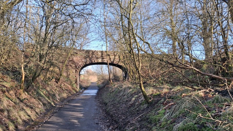
Further along our route, we pass under a stone overbridge. It is clear from the span of the bridge that the railway company intended to double the line. The south side of the track-bed is now a huge water main which runs from Loch Lomond to the east. The pipe can be seen clearly sitting under the footbridge we just crossed over the Endrick Water.

This road forms part of the West Highland Way, and we turn hard left and follow it downhill until it starts a steep ascent for about half a mile. Now and again, we come across backpackers who are making their way along the West Highland Way from Milngavie in the north of Glasgow to Fort William. A walk of around 96 miles (154km) it follows paths and quiet backroads, the journey typically taking around 6 or 7 days.

We reach the top of the hill and are greeted by fabulous views, across to Loch Lomond and the Luss Hills in the west and the Campsie Hills in the south east. It is a glorious day, and the Belted Galloway cattle come across the field to inspect us as we stop for a breather and to admire the vistas.

The cattle are in fact grazing on the site of an ancient Drumquhassle Roman Fort, which formed part of what is known as the Gask Ridge – a series of outposts across Scotland from south west to north east along the southern highland faultline.

After plateauing for a bit, the route descends towards Drymen Village, crossing the main road before arriving at this ancient market town. The village retains much of its ancient character and is home to the oldest licensed pub in Scotland – the excellent Clachan on the edge of the village square. The hostelry was originally managed by the sister of the famous outlaw Rob Roy, and has a great restaurant as well as a cosy bar. The restaurant is very popular, so booking is recommended.
Also on the square is David Macdonald’s award-winning butchers' shop, a coffee shop and a small well-stocked Spar mini-market.

We walk down the main road in Drymen, stopping for a cup of tea and a bite at the excellent, cosy, friendly Skoosh café. Inside, on the wall of the café, there is an excellent depiction of the route of the West Highland Way by the late and much-missed, highly talented local artist Alan Dewar.
After recharging, we walk down the main road for about a hundred yards and take the path opposite the entrance to the famous Buchanan Arms Hotel.

The path takes us up to a viewpoint with seating, looking west across Loch Lomond. Spectacular. A path leads off to the left-hand side at about forty five degrees, and we follow this downhill to join a larger track.

We are now heading west and downhill through picturesque woodland. Soon we come to the Home Farm and turn left to continue down the hill.
We are now in Buchanan Estate, originally home of the Duke of Montrose. The ruins of Buchanan Castle remain, having had its roof removed for tax reasons in the 1950s.

One of the castle’s claims to fame is that it is where the captured Rudolf Hess was taken after he crash landed near Eaglesham in the south of Glasgow, having reportedly flown to the UK in a bid to negotiate peace between the UK and Germany during the Second World War. (The castle had been turned into a military hospital during the Second World War)

We come to the principal road leading in and out of the estate. Had the ground been drier, we would have crossed the road and walked across what is known as Drymen Show-Field – so called because it is the site of one of the oldest, longest surviving agricultural annual fairs in Scotland. It just looked a little boggy.
The Show-Field is also the location of Drymen Curling Pond. Not used as much as it used to be, it still affords some local competitions.

We turned left and followed the road out of the estate to the main road, where we turned right to head back to Croftamie. Soon we crossed the ancient Drymen Bridge and made our way up the footpath to Croftamie Village.

This is an excellent round route and takes a couple of hours, plus any time for stopping. Great on a sunny day!


