
Cycling Along the Old Ballachulish Railway Line
- May 2
- 7 min read

Last weekend was perfect weather for our ride up the former Ballachulish Railway line. We intended to follow part of the Sustrans Route 78, which runs from Campbeltown to Inverness. The section we were going to undertake was nearly all off-road between Connel Ferry and Ballachulish, some 30 miles.
From Appletree Cottage in Croftamie, we drove to Helensburgh Upper Station. We could have cycled, which would have taken us around an hour and a half, but we decided to preserve our energy and took the bikes on the car rack. We then took the bikes on the train, which were free but required prior reservation.
The train ride from Helensburgh Upper to Oban is very scenic. It is one of the most stunning railway journeys in Scotland. Late April is a great time to travel. The leaves are not fully formed on the trees, so the spectacular views are unobscured by foliage. We travelled first along the southern shore of Gairloch, then crossed over the hills to high above Loch Long. The railway hugged the contours of the hillside as it threaded its way through the sparsely populated mountainous region. Soon we were travelling along Loch Lomondside up to Crianlarich, where one section of the line continues to Fort William and Mallaig, whilst our route turned off towards Oban. On the way to Oban, we passed along Loch Awe and then Loch Etive. We didn’t go as far as Oban but alighted one stop before at Connel Ferry village, where we had booked ourselves into the excellent Oyster Inn for the night.

The first stage of our cycling journey was to cross the massively impressive Connel Bridge. The bridge was built specifically for the railway line. For several decades after its completion, road traffic was prohibited. The only way of getting a road vehicle across was to book it on a special railway truck until the railway finally relented and created a narrow strip of road alongside the track. Nowadays, there are no trains, as the line was closed in 1966, so the bridge is used entirely for road traffic, albeit single-file and controlled by traffic lights. There is also a pedestrian walkway across the bridge.
Once over the bridge, after about 50 yards on the main road (with the bridge lights sequencing, we could choose a gap in the traffic), we turned into the first road on the left, towards the Lochnell Hotel. The cycle route was clearly signposted, and we continued for a bit along what had previously been a section of the main road.
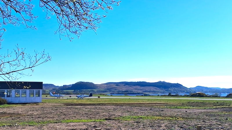
Soon, on our left, we passed along the perimeter of Connel Airfield. This small airfield is also known as Oban Airport and has scheduled flights to Glasgow in small aircraft as well as several private planes.

Shortly after passing the airport, we were on the former Ballachulish Railway line, which was both level and tarmacked. This would be the predominant surface for most of our journey. Some parts of the route took us alongside the main road, but these sections were generally short and on a reasonably wide cycle path on the pavement rather than on the road. We made a brief stop at the well-stocked Benderloch Shop, which sits beside the railway, to pick up supplies, as we wouldn't be passing another shop until Ballachulish.
Around the village of Barcaldine, we had a diversion through the trees around Barcaldine House. The route throughout is clearly marked, so it is hard to go wrong.
Soon after passing Barcaldine, we came to the edge of Loch Creran. The former railway bridge over this loch was rebuilt for traffic and opened in 1999. The bridge saves a detour of 5 miles (9km) around the head of the loch, so it is quite a time saver.
Once over the bridge, we could see one of the surviving stations on the line. Creagan Station has been beautifully preserved and now forms part of a caravan site.

An interesting note about Creagan Station is that when the line was being built, the use of concrete in railway structures was relatively new. According to Duncan Kennedy, in his excellent book The Ballachulish Line, experimental mixes of concrete, varying the amount of aggregate in each mix, were tested on the eight-foot-long platform sections at Cregan Station. He notes that returning to the platform 50 years later, he could identify differing wear on the platform panels due to the variety of mixes.

Further up the line, just after passing through the remains of Appin station (just the two platforms, but no buildings), Castle Stalker came into view at Portnacroish.
Set on a rocky outcrop in a tidal inlet known as Loch Laich, just off Loch Linnie, Castle Stalker is thought to have originally been a residential fort, built in 1320. It was used by the Macdougalls, who were the Lords of Lorn at the time. The castle then passed to the Stewarts in 1388, and the building you see today was largely due to John Stewart, who was Lord of Lorn in the 1440s.
A drunken bet resulted in the castle passing to the Campbells in 1620, who abandoned it in 1840 when the roof fell in. The castle has now been restored, is in private ownership, and is open to the public at selected times of year. It is possible to walk across to the castle at low tide, but it is not recommended as the tide can quickly return! In the distance, we could see Glen Sanda granite quarry on the Morven Peninsula.

Moving further north, our only steep climb on the route in a series of hairpin bends, took us up through the Highland Titles Nature Reserve. This is a pretty detour from the railway line, up through gentle hills studded with small lochans. There are several bird hides for twitchers overlooking the perfectly formed, placid ponds.

Descending from the Nature Reserve, we were back on the railway line, passing Duror hamlet and on towards Ballachulish.
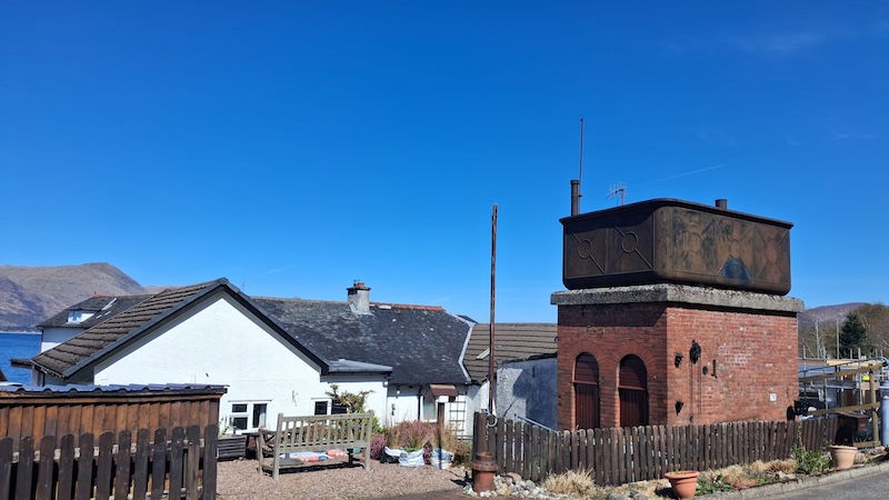
Few railway artefacts remain along the line, so it was a surprise that as we arrived at Kentallen, we were confronted by the striking remains of a water tank which was built to replenish the steam locomotives using the line. The former Kentallen station has been converted into the excellent Holly Tree hotel, although over the years, the outline of the original station building has become less distinguishable as the hotel has been considerably extended.
After Kentallen, there were some fantastic views across Loch Linnhe to Morven. Eventually, we came to the single platform of Ballachulish Ferry Station nestled in the trees. Before the modern Ballachulish Bridge was opened in 1975, there was a small ferry which carried limited vehicle traffic across the loch. The option for not taking the ferry was to drive around the loch via Kinlochleven – a detour of some 18 miles.

The main cycle route (Sustrans Route 78) continues across the Ballachulish Bridge to Fort William and then onto Inverness. However, we had set our sights for the day to go as far as Ballachulish village.
The last couple of miles to Ballachulish were next to the main road, but again on the pavement.
Once in the village, we had an excellent lunch at the Quarriers Pub. From the pub beer garden, we could see another surviving station . Ballachulish Station terminus building, now used as a doctor’s surgery has been well maintained, although there is no evidence of the platforms or other railwayana.
After lunch, it was time to return via the same route to Connel Ferry, the same thirty miles distant.

The Ballachulish Railway was built as a branch of the Callander and Oban Railway and opened in 1903. It was built principally to transport slate from the Ballachulish Quarries to the central belt, to roof some of the buildings in the rapidly expanding cities of Glasgow and Edinburgh.
The Callander and Oban railway was taken over by the Caledonian Railway, which in turn was absorbed into the London, Midland and Scottish Railway.

There was never a vast amount of passenger traffic. However, many people depended on the train to make their visits to Oban and elsewhere. There was a school train between Ballachulish and Oban, some cattle traffic and of course slate from the slate quarries. The slate quarries in Ballachulish closed in 1955. Thereafter, without the slate traffic, the line struggled on. There were up to four passenger trains a day, with an additional service on Saturdays. It took over an hour and a half to travel between Oban and Ballachulish, making the average speed of travel 20 miles per hour!

The Playhouse cinema in Oban timed its screenings to enable patrons to catch the last train out of Oban in the evening. Road traffic, however, provided too tempting an alternative for the railway customers. Eventually, with passenger numbers at an all-time low, the line fell victim to the infamous Beeching cuts. The last train ran on 26 March 1966, and the rails were lifted shortly afterwards. Had it remained open, the Ballachulish railway would surely have been a hugely popular tourist destination in the same way that the Mallaig extension from Fort William attracts thousands of visitors every year.

Our cycle ride was 60 miles, there and back and took us just under three hours each way. Having electric bikes was a bonus for the two hilly sections - one at Barcaldine and the other at the Highland Titles Nature Reserve.
More can be found out about the Ballachullish Railway here: https://rogerfarnworth.com/2019/01/01/the-ballachulish-railway-line-part-1/. and here: https://rchs.org.uk/wp-content/uploads/2021/07/The-Ballachulish-Branch-Part-2.pdf


